

A new National Institute of Advanced Studies (NIAS) portal, developed with an ISRO team, uses satellite imagery and archival research to uncover India's hidden cultural landscapes, with old Bengaluru among the sites next in line.
For most people, heritage is limited to what stands visibly before them, such as a temple, fort, palace or protected monument. "But historical landscapes often leave behind subtler traces," says Prof M B Rajani of NIAS, who leads the heritage mapping initiative.
"A buried moat may survive as a moisture line in farmland, a vanished fort wall may appear through vegetation patterns, and an old settlement boundary may continue in the alignment of present-day roads. Individually, these may seem insignificant, but together they reveal the larger historical footprint of a place," she says.
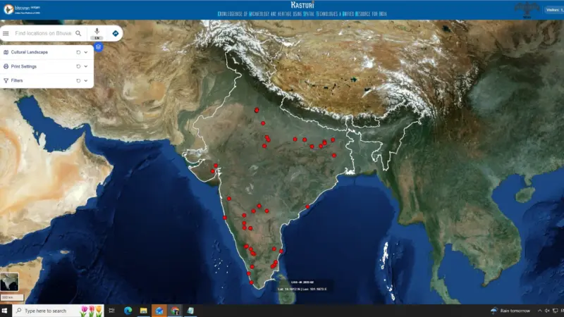
Chef's tables: Bengaluru's new culinary pursuitThis led to Kasturi, a web-based geospatial heritage portal developed by the Bengaluru-based National Institute of Advanced Studies in collaboration with the National Remote Sensing Centre and hosted on ISRO's Bhuvan platform. Inaugurated last week, it allows users to explore historical sites across India through satellite imagery, archival references, geospatial markers and curated feature-based information. The portal is named after the late Dr K Kasturirangan, who laid the foundation for geospatial heritage studies at NIAS.
"It is not simply a monument directory. We are trying to understand the larger cultural landscape around a site, how extensive it once was, what features belonged to it, and what traces of that survive even if they are no longer visibly recognised," says Rajani.
For instance, at Halebidu, the mapping exercise went beyond the Hoysala temple complex and includes remains such as moats, water systems and associated structures extending outside the protected zone. In Agra, the portal goes beyond the Taj Mahal and Agra Fort to map portions of the wider Mughal riverfront settlement, including traces of havelis that cannot be found now.
The portal currently has mapped 47 sites. Its first phase (2019-2023) focused on 20 UNESCO world heritage sites, including Agra, Bodhgaya, Nalanda, Mahabalipuram, Hyderabad, Sarnath and five different sites in Delhi. "From Karnataka, one could find Badami, Belur, Halebidu, Somanathapura and Srirangapatna among the first sites to go live. Another 27 landscapes were added as the project expanded," she explains.
Next on the map: Old Bengaluru
Among the sites to be featured in the future will be the historical Pete and Kote boundaries, the old bazaar spine centred around present-day Avenue Road, the Kempegowda-era settlement edge, portions stretching towards Majestic and the railway station, the larger fortified citadel zone, and the original historical layout of Lalbagh during the Hyder Ali-Tipu Sultan period.
Temple clusters, inscriptions and other historical markers that once formed part of the city's early urban radius will also be considered, she adds.
How to use
Users entering the portal can navigate through the country's map, which is marked with red dots. Each site can be zoomed into, while specific mapped features open as pop-up windows containing details such as name, category, description, protection status, whether the site was already known or newly identified, and its present condition on the ground.
Visit bhuvan.nrsc.gov.in/apps/kasturi