




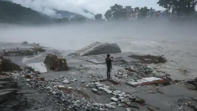

The August 26 tragedy in the Bhote Koshi-Trishuli basin is a stark reminder of the trouble brewing in the fragile Himalayan transboundary river systems.
Nearly 1,300 people were killed, and more than 5,600 were missing in these floods in Nepal, while China maintains that 21 were killed at Gyirong in Tibet.
While China's casualty figures are generally underestimated, be it in natural or human-made disasters since the Great Leap Forward of 1958-62 or the recent COVID pandemic, more significant and potentially devastating future disasters await the trans-Himalayan region due to intensive infrastructure development, including dam construction.
China has built nearly 100,000 dams, with nearly half of these on international rivers. The pace of such construction is only increasing, including in Nepal, triggering water flow, slope instability and erosion in environmentally sensitive zones.
Last July, China began construction of the world's largest dam in a fragile zone at Medok in Tibet, tunnelling through Namcha Barwa mountain on the Yarlung Zangpo River for $167 billion to generate 60 gigawatts of electricity. China's penchant for dam construction is due to its obsession with utilising all water resources while minimising external flows through transboundary rivers. In the process, Beijing is also creating leverage over lower riparian states, such as Nepal, Bhutan, India and others.
It is estimated that the total annual renewable water resources in China amount to less than 3 trillion cubic metres (tcm) (compared to less than 2 tcm in India). External flows from neighbouring countries into China are paltry, estimated at about 25 billion cubic metres (bcm), while outflows from China to neighbouring countries, through transboundary rivers or into seas, are around 700 bcm.
Nearly 40 rivers in China flow into 16 countries downstream, viz., Afghanistan, Bangladesh, Bhutan, Cambodia, India, Kazakhstan, Kyrgyzstan, Laos, Mongolia, Myanmar, Nepal, North Korea, Pakistan, Russia, Tajikistan and Vietnam. Among these, the volume of water flowing to Bhutan, India, Kazakhstan, Kyrgyzstan, Laos, Mongolia, Nepal, Pakistan and Vietnam is estimated at 718 cubic km per year.
While lower riparian states have legitimate rights over water control by upper riparian states under international law, China took two measures in internal and external balancing to maximise its gains.
Internally, China enacted the Water Law in 1988, amended later (most substantially in 2002), for regulating and using water resources. It stated that all water supplies belong to the Chinese state and only its State Council is authorised to access and regulate them. This provided absolute sovereignty over water for China. Through this law, China established water licensing and compensation systems. China had constructed dams and other water management systems to maximise its claims, create facts on the ground and avoid any binding obligations in future.
Externally, Beijing (as well as Turkey and Burundi) refused to sign the multilateral cooperative framework of the United Nations Watercourses Convention (UNWC) of 1997 that came into being in 2014. While the UNWC upholds equitable and reasonable use of waters, it also mentions a "duty to cooperate" with lower riparian states and mediation by a third party.
While China signed several bilateral agreements on transboundary rivers, detailed procedural rules or specific measures for implementation and monitoring are not outlined, leaving scope for interpretation and selective execution. Strategic leverage is one of the main reasons for not signing a treaty with lower riparian states.
For instance, out of 16 lower riparian states, China signed treaties with only four states, viz., North Korea in 1964, Mongolia in 1994, Kazakhstan in 2011 and Russia in 2008 on border delimitation and navigation. These agreements have provisions related to hydrological data exchange, joint research/monitoring, flood control and disaster management.
However, many lower riparian states were left high and dry with these agreements, as no specific water allocation formulas were made in these treaties, with issues instead addressed case by case through a ministerial committee. For instance, Kazakhstan was disappointed after China built several projects, including the Black Irtysh cascade in Xinjiang, Maybulak on the Ili and others.
Most of the water flowing into China originates in Tibet, which was militarily occupied in 1951, leaving no scope for the traditionally dependent neighbouring states. For instance, three main river systems connect Tibet with Nepal, viz., Koshi in the east (which includes the Bhote Koshi tributary, the scene of the current disaster), Gandhaki in the middle and Karnali in the west.
China had built several infrastructure projects, underground facilities and extensive tunnelling near the Tibet-Nepal border and Rasuwagadhi, the area that witnessed a major disaster recently. In addition, China constructed 60 MW Upper Trishuli 3A by 2019, 50 MW Upper Marsyangdi A in 2017, and 78 MW Sanjen Khola last year, while many are mired in corruption, environmental litigation or other charges.
In 2006, India and China issued a joint statement for hydrological data exchange and emergency response mechanisms on the Yarlung Zangpo/Brahmaputra River, while an MoU was signed four years earlier on sharing water data from Nugesha, Yangcun and Nuxia from May-October for flood forecasting, with India paying for such services at an annual fee of $120,000. However, during the Galwan border clashes in 2020, China stopped sharing such data.
However, limited and selective data sharing, lack of real-time flow data from upstream monitoring stations on transboundary rivers, stoppage of sharing such data during border clashes, and lack of clear information about runoff river or river water diversion projects have all created tensions between China and India.
Such tensions have become structural and frequent in nature between China and the lower riparian states, given China's ambition to control all water flows as well as initiate infrastructure projects in delicate environments. Thus, the Nepal disaster is no exception, but a tragedy that is likely to be unveiled in the rest of the downstream fragile ecosystems.
China's disregard of international law and assertion of absolute sovereignty over water, inability to recognise the needs and rights of lower riparian states, signing of non-binding and selective bilateral treaties, and limited, conditional and symbolic cooperative efforts without formal, reliable early-warning measures have raised concerns among lower riparian states. Disasters like Bhote Koshi give a clarion call to the lower riparian states to unite.
(The writer is a professor in Chinese Studies at JNU)