
The discussion over the world map has heated up once again. A map is going viral on social media that seems to redraw the entire world's geography.
This map is not new.
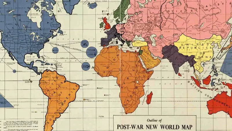
It was created in 1942 by a man named Maurice Gomburg. Maurice claimed that after World War II, major changes would occur in the world map, and only 15 countries would exist.
This map was first published in 1942 in Philadelphia, USA. Its publisher, Maurice Gomburg, was originally from Russia, but later settled in the United States. He claimed that in the future, the world map would change completely. Looking at this map, it seems that some big and powerful countries would merge with smaller nations and emerge as new superpowers.
In this map, India is mentioned as the 'Federation Republic of India.' Along with the current India, Afghanistan, Pakistan, Nepal, Bhutan, Bangladesh, and Myanmar are also shown as part of it. Interestingly, when this map was created, India was under British rule. The question arises: could the 'Akhand Bharat' shown in this map ever become a reality?
The map depicts the United States as the world's greatest power. Maurice had stated that America would not only include Canada and Mexico within its borders but would also incorporate Central America and Caribbean countries. Additionally, islands like Greenland and Iceland would become part of the U.S. territory.
South America is transformed into the 'United States of South America' (USSA), encompassing the entire South American continent. All African countries are shown merged into the 'Union of African Republics' (UAR). Middle Eastern countries like Saudi Arabia, Iraq, and Syria are grouped together to form the 'Arabian Federated Republic' (AFR). China is depicted as the 'Unified Chinese Republic' (URC), which includes China, North and South Korea, Vietnam, Laos, Cambodia, and parts of Thailand. Europe is shown as the 'United States of Europe' (USE), which includes Germany, France, Italy, Spain, and other major European countries.
This map recently became a topic of discussion when it went viral on social media. People are associating it with Donald Trump's expansionist policies. Trump had talked about incorporating Canada and Greenland into the U.S. during his presidency. Now the question arises: If these steps are taken, will Mexico be the next target for the U.S.?
This map is 82 years old, but its viral resurgence raises the question of whether the world is truly heading in a direction where geography will be completely altered. Could India once again become 'Akhand Bharat'? Is America planning to expand its borders? Looking at this map, it is clear that large countries may consider expansionist strategies to increase their power. However, there are no concrete steps visible at present, but history has shown that geography is never static. It will be interesting to see whether the ideas in this map become a reality in the future, or if it remains just a page in history.