
IBG NEWS | INVESTIGATION
Dum Dum Under Pressure - How Demography, Density & System Gaps Are Creating a Silent Security Risk
Soon, everyone will talk about these points.
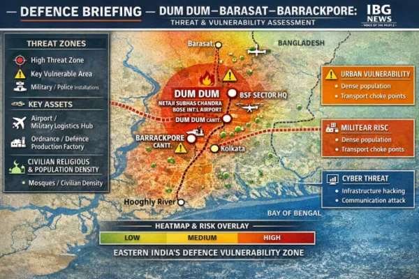
Dum Dum, Barrackpore, Barasat, this trio is another chokepoint of the Eastern theater of India. Not only key military establishments, but also the Saha Nuclear Physics and Rajarhaat New Town Salt Lake IT Sector. All are of national importance.
Most of the infiltration of the past 25 years has made the demographic composition highly vulnerable with Bangladeshi, Rohingya, Pakistani, Afghan, and other nationality, 80% of infiltrators are economic opportunists who came for a better life, and definitely some "Dhurandhars" of other nations are in the visibility.
If a survey by IB is conducted, anyone can find that most of the cleaning staff of Indian origin has been strategically replaced by these doubtful infiltrators. They have access to key establishments and chokepoint controls for water, electricity, Rail and Airport.
Local political mafia leaders are using them for vote bank politics. Even though they are doing the regular reki for Terror groups and a passive surveillance on critical families of security and defence personnel.
These terror elements are now busy establishing trust with locals and purchasing the small and mid-level leaders of political parties with social bribes. Every region has this group of D staff, but if you analyze, you will see a sudden surge in delivery persons, house maids, and cab drivers from a section has increased manyfold across India. In this region, most of them travel from the nearest border areas, thanks to rail connectivity. So Nadia,24 Pargana south and north create a daytime demography change upto 50:50 ratio.
Recent Malda Kaliachak type blockage, even for an Army convoy, is just a blink of an eye event.
Local civilian authorities are getting external funding to oversee this, according to many informed sources. ED can do the due diligence and clear the doubts.
Let's dig into the points.
Location Focus: Kolkata North Corridor
Strategic Assets: Netaji Subhas Chandra Bose International Airport | Dum Dum Cantonment
📍 THE BIG PICTURE
Dum Dum is not just a suburb-it is a high-value strategic zone embedded inside one of India's densest urban clusters.
👉 The result:
A critical logistics hub operating inside a complex, partially unverified urban environment
Population Density vs Strategic Risk
| Zone | Population Density | Strategic Assets | Risk Level |
| Dum Dum Core | Very High | Airport + Cantonment | 🔴 High |
| Nagerbazar-Kaikhali | Very High | Airport proximity | 🔴 High |
| Barasat Axis | Medium-High | BSF coordination | 🟠 Medium |
| Barrackpore | Medium | Cantonment | 🟡 Medium |
👉 Insight:
Risk increases where density overlaps with strategic infrastructure
⚠️ THE CORE ISSUE: SYSTEM GAPS, NOT PEOPLE
This investigation highlights three structural vulnerabilities:
🧩 1. Documentation & Identity Gaps
👉 Outcome:
Reduced traceability in high-security zones
🧩 2. Urban Congestion as a Security Risk
👉 In crisis scenarios:
📊 INFOGRAPHIC BLOCK 2
Types of Vulnerability
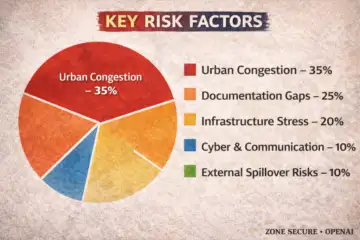 Risk Factor
👉 Insight:
Most risks are internal and structural-not external attack-driven
🧩 3. Proximity Risk: Civilian-Military Overlap
- Airport perimeter
- Military zones
👉 This is a classic "urban encirclement of strategic assets" problem
Threat Scenarios (Simulation Model)
| Scenario | Trigger | Impact Level |
| Transport Gridlock | Civilian congestion | 🔴 High |
| Coordinated Disruption | Multi-point disturbance | 🔴 High |
| Identity-Based Security Breach | Documentation gaps | 🟠 Medium-High |
| Cyber Disruption (Airport/Rail) | Infrastructure attack | 🟠 Medium |
🧭 DEFENCE PERSPECTIVE
From a military standpoint:
👉 If disrupted:
📊 INFOGRAPHIC BLOCK 4
Risk Heatmap Logic (For Your Poster)
Overlay layers:
🛡️ WHAT NEEDS TO CHANGE
Immediate
Structural
Here's a clear, factual inventory of ordnance/defence manufacturing establishments in the Dum Dum - Barrackpore - Barasat belt (North Kolkata industrial-military corridor). This area is historically one of India's oldest small-arms and materials production clusters.
Region Anchor: Kolkata North Corridor
Location: Ishapore (near Barrackpore)
Established: 1904 (British India)
- INSAS rifles
- 7.62 mm rifles (new generation variants)
- Assault and infantry weapons
- Indian Army
- Central Armed Police Forces
Location: Ishapore (adjacent to RFI)
- Small arms
- Defence equipment
- Armament components
👉 But historically, this region laid the foundation of India's ordnance ecosystem
- Logistics corridor
- Storage / movement zone for supplies
👉 Supports:
| Facility | Location | Type | Status | Role |
|---|---|---|---|---|
| Rifle Factory Ishapore | Barrackpore belt | Small arms | Active | Infantry weapons |
| Metal & Steel Factory | Ishapore | Metallurgy | Active | Defence-grade steel |
| Dum Dum Ammunition Legacy | Dum Dum | Ammunition | Historical | Foundation role |
| Barasat Corridor | Barasat | Logistics | Active | Supply movement |
This region forms a complete defence production ecosystem:
👉 Very few regions in India have this end-to-end chain in such close proximity
"Eastern India's legacy small-arms manufacturing spine with integrated logistics support."
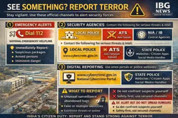
What to do?
"Dum Dum's vulnerability is not about who lives there-it is about how little the system knows, manages, and secures one of India's most critical strategic corridors."
So immediate background check of the tenants and house helpers, and pattern analysis of cab drivers from this region. All municipality stafss regular or temporary, small vendors must be verified. All security and defence families must check the vendors and small sellers they interact with. Analyse the CC TV camera footage for similar patterns of movements.
A big security lapse is already present due to civil authority negligence, and election time free movement has triggered a red alarm for all, be alert be observant if any doubts occur, and inform authorities.