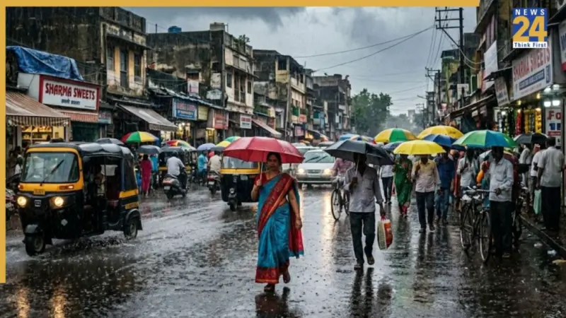

India is currently witnessing two completely contrasting faces of nature at the same time. While people across northern and central India are being forced indoors due to scorching heat and blazing afternoons, moisture-laden monsoon winds from the southeast Arabian Sea and the Bay of Bengal have already begun entering the country.
The India Meteorological Department (IMD) on Saturday officially announced that the southwest monsoon has advanced into the entire Nicobar Islands, the Andaman Sea and parts of the Bay of Bengal. However, behind this early arrival lies the growing threat of El Niño, a climate phenomenon that could leave large parts of the country struggling with water shortages in the coming months.
Early monsoon arrival raises hope
According to the IMD, weather conditions are currently highly favourable for the further advancement of the monsoon. Over the next three to four days, the monsoon is expected to move deeper into parts of the southeast Arabian Sea and the east-central Bay of Bengal.
Normally, the monsoon reaches the Kerala coast around June 1, marking the official beginning of India's four-month rainy season from June to September. This year, however, it is likely to arrive nearly a week early, around the morning of May 26, 2026, with a possible variation of four days on either side.
This will be the third consecutive year that the monsoon has arrived ahead of schedule. In 2024, it reached Kerala on May 30, while the previous year it arrived as early as May 24.
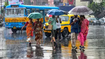
As a result, cloud cover, gusty winds and pre-monsoon rainfall activity have already intensified across parts of Tamil Nadu, Kerala and coastal Karnataka.
'Super El Niño' threat looms over rainfall
Despite the strong and early start to the monsoon, the IMD's long-range forecast paints a worrying picture. Meteorologists have warned that total rainfall during this year's monsoon season may remain at only 92 percent of the Long Period Average (LPA), placing it in the 'below normal' category.
What is El Niño?
El Niño is a natural climate cycle that develops when sea surface temperatures in the equatorial Pacific Ocean become warmer than normal. This year, there is an 82 percent chance that the phenomenon will become fully active by July.

When ocean temperatures rise by more than 2 degrees Celsius, the event is classified as a 'Super El Niño.' Such conditions disrupt global wind patterns and weaken the southwest monsoon winds over India.
Its impact is expected to become more visible during August and September, when rainfall may decline sharply. According to estimates, the probability of drought-like conditions in India this year stands at nearly 35 percent, more than double the risk seen in normal years.
Weather experts point out that severe droughts in 2015 and 2023 were also linked to El Niño conditions.
The changing weather patterns over the Pacific Ocean could trigger sharply different weather conditions across India.
North and West India face heat and drought risk
Agricultural states such as Punjab, Haryana, western Uttar Pradesh and Rajasthan are expected to face the harshest impact of El Niño this season.
Delhi-NCR and several northern states could witness severe drought conditions during the latter half of the monsoon, especially in August and September. This may put immense pressure on kharif crop sowing, rural incomes and electricity supply.
Southern states warned of flood threat
While northern India may struggle with water shortages, the unusual effects of El Niño could bring extremely heavy rainfall and destructive floods to parts of Tamil Nadu and coastal Andhra Pradesh.
Northeast India at risk of landslides
The weather is expected to remain unstable across the northeastern states this week. Heavy rainfall may trigger waterlogging in low-lying areas of Assam and increase the risk of landslides in hilly regions.
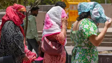
Even as the monsoon advances over the seas, there is little immediate relief in sight for northern and central India. The IMD has issued a severe heatwave alert for Uttar Pradesh, Rajasthan, Madhya Pradesh, Punjab, Haryana, Delhi and Chhattisgarh for the next week.
Uttar Pradesh records extreme temperatures
Uttar Pradesh has been reeling under intense heat over the past few days. On Saturday, Banda recorded a temperature of 44.8 degrees Celsius, while Jhansi registered 44.1 degrees and Prayagraj touched 44 degrees Celsius.
Between May 19 and May 22, temperatures in the state could break several previous records.
Western Rajasthan is entering another phase of intense heat. However, between May 17 and 18, regions including Bikaner, Jaipur, Shekhawati and Bharatpur may witness dust storms and light rainfall accompanied by winds blowing at speeds of 40 to 50 kmph.
Delhi-NCR to witness dust storms
Delhi is also likely to experience strong dust storms, thunderstorm activity, lightning and light rainfall on May 17 and 18. Despite this, temperatures are expected to remain between 42 and 43 degrees Celsius, resulting in uncomfortable humid conditions.
IMD plans heatwave rule changes; IOD offers hope
Amid the growing weather crisis, two major developments have emerged from the IMD.
The weather department is preparing to revise India's existing heatwave criteria to better reflect changing climatic and geographical conditions, including rising humidity levels.
Meanwhile, the Indian Ocean Dipole (IOD) remains the only major factor that could offset some of El Niño's damaging effects. If the IOD strengthens during the later months of the monsoon season, it may help revive rainfall activity in certain parts of the country.
With more than half of India's population and nearly 60 percent of its farmers directly dependent on monsoon rains, scientists have advised governments to begin preparing emergency plans for water management and irrigation well in advance.