
While Mumbai squeezed itself into slums, a city five hundred kilometres north grew fast and stayed mostly legal - using a planning tool from 1915 that almost no one outside the trade has heard of.
In my last piece, I wrote about Mumbai - about how fifty years of well-intentioned rules squeezed a rich city into slums, and how the people who held the rulebook never quite believed in the city they were ruling.
The natural question that essay leaves behind is whether any Indian city has done better. Whether the failure is the rulebook's, or India's. This piece is my attempt at an answer, and the answer lives five hundred kilometres north of Mumbai, in a city most readers have never thought hard about.
If you grew up outside Ahmedabad, the city is hard to place. It is not the capital of anything important; Gandhinagar is. It is not glamorous, the way Mumbai is. It is not political, the way Delhi is. It is not techy, the way Bengaluru is. People who know textiles know it. People who follow Modi know it. Most other Indians, even fellow city-dwellers, know it only as a name on a map and a flavour of dhokla.
Of all the large Indian cities, Ahmedabad is the only one that, for the last twenty-five years, has done something close to what urban planning is supposed to do. It has grown fast, without producing the slum cordon that defines Mumbai, Delhi, Bengaluru, and Kolkata. It has expanded by tens of square kilometres without bulldozing peasants or fighting decade-long land cases. It has built India's first proper bus rapid transit. It has reclaimed a forgotten river. It has gone from one of the country's more polluted, more chaotic municipal corporations to one with a reputation for getting things done.
And it has done all this while keeping its slum population to about a quarter of the city, against Mumbai's half.
The story of how is not flashy. There is no Atal Setu, no Coastal Road, no million-person slum being rehoused. There is, instead, a quiet planning instrument from 1915 that almost no one outside the trade has heard of. There is a 1999 amendment to a state act that no Indian newspaper put on the front page. There is a generation of Ahmedabad-trained planners and architects who took the boring parts of the job seriously. This essay is about why, in Indian urbanism, boring may be the highest compliment.
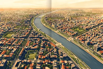
Amdavad aerial view.The city the river made
Ahmedabad sits on the river Sabarmati, which is dry for nine months of the year and a torrent for the other three. The Sabarmati separated two worlds - the densely packed walled city on the east, with its pols, havelis, and Jain temples, and a quieter expanse of farmland on the west. A railway bridge came in the nineteenth century, the textile mills came in the twentieth, and slowly the western bank filled in too, but the river remained psychologically central.
Geography did Ahmedabad two favours that Mumbai never had. First, it is flat - a plain that runs in every direction for hundreds of kilometres before the land starts to crinkle near the Aravallis. There is no sea hemming it in, no escarpment, no creek. If the city wanted to grow north, south, east, or west, it could.
Second, Ahmedabad's hinterland is farmland of modest economic value, held in small parcels by ordinary cultivators. It is not the kind of land that produces oligarchic real estate dynasties or organised farm-belt resistance. When the planners came to it, it came back.
These are not minor advantages. A great deal of what is often praised as Ahmedabad's planning genius is, at root, Ahmedabad's geographic luck. But geography only buys you a chance. Whether you take the chance is up to you. Many flat Indian cities with cheap peripheries have wasted that opportunity completely. Ahmedabad, eventually, did not.
The plan that did not quite work
Ahmedabad's first Development Plan was sanctioned in 1965, under the Bombay Town Planning Act of 1954 - the same legal apparatus, give or take, that Bombay itself was using. The plan was, in its way, ambitious. It zoned the agricultural land east of the city for new industrial estates, established by what would become the Gujarat Industrial Development Corporation. It proposed a green belt around the entire built-up area, modelled on the British inter-war fashion, to contain the city's outward spread. And it introduced floor space index limits for the first time, on the same socialist-era logic that animated Bombay's 1967 plan: keep buildings small, the planners reasoned, and the city would stay manageable.
The Development Plan of Ahmedabad, 1965. The green outline marks the proposed green belt, the central spine is the Sabarmati, and the original walled city is the dense cluster on the east bank.Look at the 1965 plan as a picture, and you can see the planner's instinct: contain, restrict, channel. The green belt around the city was supposed to be its outer limit. Beyond it, things would stay green and rural. Inside it, the planners would lay out roads in neat concentric rings.
None of this quite worked. The industrial estates on the east side - Naroda, Vatva, Odhav - did come up, and they pulled tens of thousands of workers in from rural Gujarat, just as planned. What was not planned was where those workers would live.
Public housing in the formal city remained scarce, the FSI cap kept the legal supply small, and so the workers settled in informal colonies on the periphery, often just outside the green belt, often on land the plan had marked as agricultural. The green belt itself was steadily de-notified through the 1970s and 1980s, plot by plot, as political pressure mounted. The plan that was supposed to contain the city instead just shifted where the unauthorised parts of it sprang up.
By the mid-1990s, the situation in Ahmedabad was, on the surface, almost identical to that of every other big Indian city. A statutory development plan was in place but mostly ignored. FSI limits were too low for the demand. Public acquisition for parks, schools, and roads was theoretically possible but practically stalled by litigation and lack of money. The land cadastre was a mess. Informal housing was growing faster than legal housing.
The turning
Most cities, faced with this situation, do nothing. They write a new plan saying the same things, hire a new commissioner, and wait.
Ahmedabad and its state did something different. In 1999, the Gujarat government quietly amended the Gujarat Town Planning and Urban Development Act of 1976. Almost no one outside the planning profession noticed at the time. The amendment did three things, each of which sounds technical and dull, and each of which, in combination, changed how the city grew.
First, it raised FSI limits. The central city went from a permissible FSI of around 1.0 to between 1.8 and 5.4 depending on location, with the densest values along arterial roads. Where Mumbai was still tightening, Ahmedabad was relaxing.
Second, it zoned an enormous additional area - more than a hundred square kilometres on the city's periphery - for new residential development. The green belt logic was abandoned. The planners had finally accepted what the city had been telling them for thirty years: it was going to grow, and the question was whether the growth would be serviced or unserviced. They chose serviced.
Third, and this is the one that mattered most, it abandoned, as a matter of practice, the principle that the state would compulsorily acquire private land for public purposes. Instead, the city would rely on a much older mechanism, dating back to the colonial period, that had been sitting more or less unused on the statute books for decades. The mechanism was called the Town Planning Scheme. It is the thing that, more than any other single tool, explains how Ahmedabad ended up the way it did.
Hold that name for a moment. We will come back to it.
How Ahmedabad got its reputation
The fifteen years from 1999 to 2014 are the period in which Ahmedabad built whatever reputation it now has. Not all of the work was the result of the 1999 amendment, but the amendment created the conditions under which the work could happen. Three projects from that period are worth dwelling on, because they all illustrate something about how the city had begun to operate.
The first was the Sabarmati Riverfront. The idea of doing something about the river had been floating around since the 1960s. The river had become, by the 1990s, an embarrassment: sewage-choked, edged with informal settlements, used for everything from open defecation to circus grounds. In May 1997, the Ahmedabad Municipal Corporation set up a special-purpose vehicle (SPV), the Sabarmati Riverfront Development Corporation Limited, to plan and execute a riverfront. Bimal Patel, an architect trained at Berkeley and CEPT, was given the master plan brief. Ground was broken in 2005. The first stretches opened to the public in 2012.
The riverfront, today, is 11.5 kilometres of continuous paved promenade along both banks, with parks, gardens, an amphitheatre, sports grounds, and a pedestrian Atal Bridge across the water. It draws birds and families in equal measure. Phase 2, extending the promenade northward, is under construction. Phase 3, which will eventually link Ahmedabad's riverfront to GIFT City and Gandhinagar, has been announced.
Critics say the project displaced more than ten thousand riverbed families, many of whom received inadequate or distant rehabilitation. The riverfront is not an unalloyed success, and any honest account of Ahmedabad's transformation has to record what it cost. But what is striking, even to the critics, is that the project happened. A piece of complex, multi-stakeholder urban infrastructure, conceived in 1997, was actually delivered to the public starting in 2012. In how many Indian cities is that a sentence one can write?
The second was Janmarg, India's first full bus rapid transit system. Designed by CEPT University, financed by a JNNURM grant and a state-level SPV, and inaugurated in October 2009 with a single Pirana-to-RTO corridor, Janmarg now runs to 167 kilometres of network with around 165,000 daily passengers. It has dedicated bus lanes down the median of the city's arterial roads. It has level-platform boarding, off-board ticketing, automated doors, and air-conditioned buses.
By international standards, Janmarg is a competent BRT system, not a great one. By Indian standards, given how poorly the attempts in Delhi and Pune went, it is a small miracle. It won, within four years of opening, the international Sustainable Transport Award, a United Nations "Lighthouse Activity" award, and a Silver rating on the international BRT Standard. It demonstrated, before any Indian city had built a metro outside Delhi and Bengaluru, that mass transit at the scale Indian cities need could actually be delivered.
The third was the metro. The Ahmedabad Metro's first short stretch - six kilometres between Vastral and Apparel Park - opened in March 2019. By October 2022, the entire 32-kilometre Phase 1, with two crossing corridors and a meeting station at the old high court, was operational. By December 2024, Phase 1 was 40 kilometres complete with 31 stations. Phase 2, which runs north into Gandhinagar via GIFT City and Mahatma Mandir, opened in stages from September 2024 and was fully commissioned by January 2026.
Notice the sequencing. Riverfront SPV in 1997. BRT in 2009. Metro in 2019. Each project built on the institutional capacity created by the one before. Each one was delivered, more or less, on the timeline announced, which is not nothing. Compare this with Mumbai, where the metro was promised in the early 2000s and the first underground line opened only in 2024.
One more thing happened in this period that deserves a mention. In July 2017, UNESCO inscribed the historic walled city of Ahmedabad on the World Heritage List - the first Indian city to receive that designation. The walled city is the part of Ahmedabad that is, in many ways, in the worst physical shape; its conservation remains contested and underfunded. But the inscription mattered because it signalled, to the city and to itself, that the old core was worth protecting on its own terms, not just as scenery for tourists.
The quietest tool in Indian urbanism
Now we can come back to the Town Planning Scheme.
It is the technical mechanism that makes everything else possible. Most people who have lived in Ahmedabad their whole lives have never heard the phrase. Almost no national newspaper writes about it. Its legislative basis sits in a state act last amended in the 1990s. And yet the Town Planning Scheme is silently doing more for urban India than any number of glossy mission statements.
Here is what it does. Imagine a piece of farmland on the periphery of a city - say five square kilometres, owned by perhaps two hundred different farmers in plots of various sizes. The city wants to expand into this area.
The conventional approach - the Mumbai approach, the Delhi approach - is for the state to compulsorily acquire whatever land it needs for roads, schools, parks, public housing, sewer lines, and so on. The farmers fight, sometimes for decades. The state eventually pays them market compensation, which it cannot always afford, and which they think is too low. The development is delayed, often forever. The city, meanwhile, grows into the same land informally, without any of those roads or schools or sewers.
The Town Planning Scheme takes a different route. The planning authority - in Ahmedabad's case, AUDA, the urban development authority - declares an intent to plan a particular area. It draws up a scheme that lays out the future roads, public open spaces, plots for schools and clinics, areas for affordable housing, and so on, all on top of the existing pattern of farm holdings.
It then does something that sounds counterintuitive. Each existing farmer is given back a smaller plot, usually around 60 per cent of what he started with, but the smaller plot is now serviced, with road access, drainage, and clear title in the new layout.
The remaining 40 per cent of the land is pooled. A portion of it becomes roads. A portion becomes parks and amenity plots. A portion is set aside for low-income housing. And a critical portion - the surplus, perhaps fifteen per cent of the total area - becomes saleable plots that the planning authority can auction off to fund the infrastructure of the scheme itself.
The scheme, in other words, pays for its own roads and sewers and parks. The state contributes the planning expertise. The landowners contribute land. The public gets a serviced new neighbourhood. The original landowners get back a plot that is, by every realistic measure, worth several times what they started with.
It sounds too good to be true. There are catches. Negotiating the scheme takes years - typically four to eight from declaration to final implementation. Some landowners hold out, and the law has had to be amended periodically to deal with them. The 40 per cent contribution is a hard ask in poorer pockets where farmers do not believe their final plot will appreciate enough to compensate. And the surplus-plot auctions, when they happen at the wrong moment in the property cycle, can fall flat.
But it works often enough to matter. In the twenty years before the 1999 amendment, only eighteen TP Schemes covering about 2,300 hectares were completed in Ahmedabad. In the two decades since, fifty have been completed covering more than 5,000 hectares, and another forty-seven covering nearly 4,900 hectares are in process.
The peripheral neighbourhoods that have come up under these schemes - the western developments along S.G. Highway, the eastern expansions beyond Naroda, the recently planned areas towards Sanand - are, by Indian standards, well-serviced. They have actual roads, actual sewers, actual storm drains, actual reserved school plots. They look planned because they were planned.
A schematic showing the full sequence of the Ahmedabad TPS process, from sanction of the DP through plot reconstitution to final development.The TPS is not a Gujarati invention. Its legal basis is the Bombay Town Planning Act of 1915, drafted under British rule and modelled on similar instruments in early twentieth-century England. The Maharashtra successor act has the same provisions on its books to this day. The difference is that Maharashtra largely stopped using the mechanism after the 1960s, and Gujarat quietly, methodically kept it alive, refined it through repeated amendments, and made it the default tool of city expansion. The genius, if there is one, is institutional rather than intellectual. The state stuck with a tool long enough to get good at it.
Income distribution and housing stock in Ahmedabad, c. 2008. Bungalows, apartments, and twin/row houses serve the upper three deciles; EWS/LIG public housing, chawls, and slums absorb the bottom seven.The bars on the left are the lowest-income households, the ones earning less than Rs 10,000 a month. The bars on the right are the wealthiest. The shaded categories show what kind of housing each income band has access to - bungalows and apartments at the top, walled-city tenements and chawls in the middle, slums and pavement dwellings at the bottom. The dashed line, climbing from left to right, is the cumulative percentage of households.
The picture in Mumbai is similar in shape but worse in proportion: there, the slum band stretches across more than half the income distribution. In Ahmedabad, it stops earlier. The difference is not because Ahmedabad's poor earn more - they typically earn less, in absolute terms, than their Mumbai counterparts.
The difference is that Ahmedabad has more legal housing stock to absorb the lower-middle deciles, partly because of higher FSI in the formal areas, partly because the TPS expansions have produced serviced plots that small developers can build cheap apartments on. A clerk earning Rs 30,000 a month who would live in a chawl room in Mumbai can, in Ahmedabad, get a one-bedroom flat in a Naroda walk-up. He still does not live well, but he lives legally.
This is the entire argument compressed into one observation. The point of urban planning is not to produce a beautiful city. The point is to produce a city in which working people can find a roof through legal channels. Beautiful cities are nice when you can get them. Legal housing is what changes lives.
What a layman should take away from all this
It is tempting, looking at Ahmedabad, to draw the wrong lesson. The wrong lesson is that Gujarat is special - that something about its political culture or its commercial pragmatism produces results no other state could replicate. This is the kind of thing that sounds like an explanation but is really an excuse for the cities that have not done what Ahmedabad has.
The right lesson is duller and harder. Ahmedabad's transformation is not the result of any one big idea. It is the result of one medium-sized idea - that the state should help organise land, not take it - applied steadily over twenty-five years, by a sequence of municipal commissioners and chief ministers and planning consultants who mostly did not get famous.
The Town Planning Scheme is not a clever invention. It is an old tool, with a hundred-and-ten-year-old legislative pedigree, picked up and used until it began to work. The Sabarmati Riverfront was not a stroke of genius. It was an SPV in 1997 that survived fifteen years of bureaucratic continuity. Janmarg was not a moonshot. It was a competent CEPT engineering project that the state government decided to actually fund.
Indian cities are not failing because they cannot imagine better. They are failing because they cannot execute what they have already imagined. The boring secret of Ahmedabad is that, somewhere along the way, it learned how to execute - slowly, imperfectly, with grumbles and exceptions and a few large mistakes, but consistently enough that, twenty-five years in, the city has compounded into something visibly different.
The next time you walk down a Mumbai street and find yourself wondering why nothing works, remember that less than five hundred kilometres north, a city of nine million people figured out - quietly, methodically, without much fuss - how to make most of it work most of the time. The question is not whether their model is reproducible. The question is why the rest of urban India has chosen not to reproduce it.