
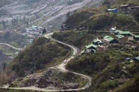

The Union government is overhauling its approach to building highways in India's hill states, with a new emphasis on stabilising slopes before road construction begins in mountainous terrain, Business Today reported .
Union Minister Nitin Gadkari, speaking at a landslide mitigation workshop in New Delhi, said that constructing climate-resilient infrastructure in the Himalayas remains a formidable challenge given the region's fragile geology, steep terrain and vulnerability to landslides and cloudbursts.
The decision to prioritise slope treatment upfront is aimed at improving the durability of national highways and cutting down on repeated repair costs.
The Ministry of Road Transport and Highways is forging technical partnerships with multiple agencies to tackle geotechnical risks more effectively.
THDC India Limited will assist with landslide remediation in Uttarakhand and Arunachal Pradesh, while the Defence Geo-informatics Research Establishment will contribute to hazard mapping.
The Geological Survey of India will provide geological data for tunnel and corridor projects, and the National Institute of Rock Mechanics will handle design reviews, safety audits and monitoring of high-risk stretches.
In a significant technological step, the government is rolling out satellite-based InSAR monitoring along a 100-km section of the Chardham route in Uttarakhand.
This system is expected to deliver early landslide warnings and reduce disruptions along one of India's most strategically and religiously important highway corridors.
IIT Roorkee is also developing guidelines for assessing hillslope instability and building real-time risk monitoring frameworks.
Going forward, detailed project reports for hill roads will incorporate landslide susceptibility maps, historical failure data and high-resolution terrain models. Tools such as LiDAR and drones will be used for better route planning.
The broader shift from reactive repairs to preventive engineering may raise initial project costs but is expected to lower long-term expenditure.
Recurring landslides have been a major driver of cost overruns, delays and safety hazards in Himalayan road projects across Uttarakhand, Himachal Pradesh and the Northeast.
New Saryu Bridge To End 90-Km Detour For Remote Uttarakhand Villages