




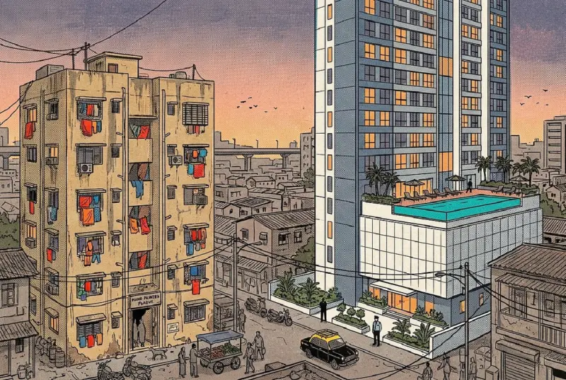

Mumbai is not crowded because Mumbaikars are too many. The 30-storey market-rate block beside the 7-storey rehab building is not an accident of redevelopment.
It is crowded, in the particular and miserable way that it is, because for too long the people who held the rulebook did not quite believe in the city they were ruling.
Ask anyone who lives in Mumbai how big their house is. Watch them hesitate.
A Mumbai flat is small. Smaller than people from other Indian cities expect. Smaller than the same money buys anywhere else. The middle class lives in one-bedroom flats the size of a guest room in a Delhi house. The working class lives in chawls and shared single rooms. Roughly one in every two Mumbaikars lives in a slum.
Most people, including most Mumbaikars, treat this as a fact of geography. The city sits on a thin strip between the Arabian Sea and the Western Ghats; there is only so much land; what can you do. But this is the wrong diagnosis. Mumbai's housing problem is not a shortage of land. It is a shortage of permission to build on the land it has.
For fifty years, the city has been forbidden by its own rulebook from using its plots the way almost every other major world city uses theirs. The crowded, expensive, half-informal Mumbai that millions of us know is what those rules built. The city is now, after decades of caution, building at speed; bridges over the sea, a metro underground, a million slum-dwellers being rehoused. Whether any of this corrects the old mistake, or sets it more firmly in concrete, is the question that hangs over the next decade.
The Seven Islands That Became a City
Mumbai began as seven swampy islands. That is genuinely all there was, a string of muddy hilltops poking out of the Arabian Sea between Colaba and Mahim. Over two centuries, the British filled the channels in, sometimes by dumping rubble, sometimes by building causeways. By the time the colonial state handed the city back to itself in 1947, the seven islands had become one. 69 sqkm. of municipal area, shaped like a kitchen knife pointing south into the sea.
The Seven Islands That Became a City.In 1957, ten years after independence, the city's jurisdiction was extended northward. The new boundary captured 368 sqkm. of suburbs and salt pans, taking the total to 437. This is now Greater Mumbai, run by a single municipal corporation. The shape, however, never lost its old constraint. Mumbai is a long, narrow city with water on three sides. You cannot grow west, because there is the Arabian Sea. You cannot grow east, because there is Thane Creek and then the Western Ghats. You can only grow north, slowly, and so the city did.
In 1964, the city produced its first Development Plan. The document, sanctioned three years later, was a fine piece of post-independence ambition. Mumbai would become "a worthy capital of Maharashtra", a "commercial and industrial centre", and "above all a cherished home for its teeming millions". It would have neighbourhoods with a sense of "healthy interdependence". It would have a density of between 250 and 600 people per acre. It would have one acre of open space for every 1,000 people. It would decongest itself by discouraging the expansion of industry.
It did not become any of these things. Or rather, it became all of them in name and almost none of them in fact. The plan had no monitoring system, no way to check whether its objectives were being met. It assumed the planning authority could compulsorily acquire enormous tracts of private land. It assumed the central government would write large cheques. Neither assumption survived contact with reality.
To plan a city without an evaluation system is, in retrospect, an interesting kind of confidence. It is the planner's equivalent of writing a novel and never reading it back.
The Rulebook That Held the City Down
To understand Mumbai's crowding, you have to understand a single, dull abbreviation: FSI. Floor Space Index. If you have never heard of it, you have spent your life living inside its effects, like the air pressure you do not notice until it changes.
Here is what it means. If you own a piece of land of, say, a thousand square metres, and the FSI permitted on that land is 1, you can build buildings whose total floor area adds up to a 1000 sqm. One floor covering the whole plot. Two floors covering half. Four floors covering a quarter. The shape is up to you, the total is not. If the FSI is 3, you can build 3,000 sqm. If it is 10, then 10,000 sqm.
Until 1964, Mumbai did not really use FSI. Buildings were controlled by other things; coverage, number of storeys, the angle at which light had to reach the street. Chawls in the older parts of the city, the kind built before 1940, had effectively consumed an FSI of about 3.5. South Mumbai's apartment blocks ran at similar densities. This was not because of any law. It was because of demand. People needed places to live and work, and the buildings grew to accommodate them.
The 1967 plan changed everything. It introduced FSI as a tool of population control. The new rules permitted 1.66 in older parts of south Mumbai. 1.33 in Malabar Hill and Dadar-Matunga. 1, just 1, in the suburbs. Some pockets, like the freshly reclaimed Nariman Point, were given 3.5, mainly because they had been planned at higher densities from the start. By the time the next plan was finalised in 1991, the logic had been sharpened further. The entire island city would have an FSI of 1.33. The entire suburbs, 1. Uniformly. Across one of the most varied urban geographies in Asia.
The reason given was decongestion. The idea was that if you stopped people from building tall, people would stop coming. They would settle elsewhere. The city would breathe.
People did not stop coming. The city did not breathe. What actually happened was simpler and uglier. Demand for housing in Mumbai kept rising because the jobs were here, the schools were here, the trains ran from here and the legal supply was held artificially short. So a parallel housing market grew up, one that did not respect FSI or any other regulation, one that built informally on whatever vacant land it could find. The slum.
The share of Mumbai's population living in slums, compared with Ahmedabad, between 1971 and 2001.The upper line is Mumbai. The lower one is Ahmedabad. The lines are not a story of poverty. Mumbai's average household incomes rose, in those three decades, by around ten per cent a year. The lines are the story of legal supply failing to meet a demand that grew with prosperity. People got richer and still ended up in slums, because the only housing they could afford was the kind that broke the rules.
Compare Mumbai's old FSI of 1.33 with the densest parts of other cities. Manhattan permits an FSI of around 15. Hong Kong, around 12. Shanghai's central districts, 8 to 10. These are not slums. These are the cores of the most expensive real estate markets in the world. The point is not that Mumbai should look like Manhattan. The point is that the rule itself "keep FSI low and the city will be less crowded" has no basis in how cities actually work. People do not vanish when you tell developers they cannot build. They simply get worse housing.
This is the elementary fact that the city refused to learn for half a century. It cost a generation of Mumbaikars their right to a roof.
The Lost Mills
Mumbai had a different chance in the 1980s and 1990s, and squandered it.
The cotton mills of central Mumbai; Parel, Lower Parel, Worli closed slowly through the 80s and were gone by the mid-90s. They left behind something this city almost never gets: large, contiguous tracts of land in the middle of the city, owned in the main by a small number of mill-owning families and trusts. 700 acres.
The 1991 Development Plan tried to do something sensible with them. It introduced a one-third rule. When mill land was redeveloped, 1/3rd of the area would go to the mill owner for commercial redevelopment, 1/3rd to the municipal corporation as public open space, and 1/3rd to the housing board for public housing.
Then came 20+ Years of negotiation, litigation, lobbying and quiet pressure. By the time the dust settled, the formula had been gutted. The mill owners and their successors kept most of the land. Public housing got almost nothing. Open space got the leftovers small, fragmented parcels where what the city needed was a Central Park.
It is hard to overstate the magnitude of this loss. In the heart of Mumbai, the city had been handed a once-in-a-century opportunity to add lungs, parks, and tens of thousands of public flats within walking distance of trains and jobs.
It walked away with a few glass towers, a strip of high-end retail, and a string of nightclubs that taxi drivers refer to by ordinal numbers. The people who work in those towers now live in suburbs an hour and a half away. The mill workers families, the ones who could have lived in public housing right where they had grown up, were dispersed.
When the Government Discovered That FSI Could Be Sold
In 2008, the Congress-led state government had a budget gap. It found a way to fill it. The government announced that builders in Mumbai would now be allowed to buy extra FSI from the state by paying a premium. The revenue would be shared between the state and the Municipal Corporation.
This was a remarkable announcement, when you stop to think about it. The same low FSI that had been keeping the city compressed for 40 years had suddenly become a saleable asset. The state was not relaxing the rule. It was monetising it. If you had money, you could buy your way past the rule. If you did not, you stayed in the chawl.
Courts struck the policy down because no law empowered the government to sell development rights this way. The government's response was elegant in its cynicism. It retroactively amended the Maharashtra Regional and Town Planning Act of 1966 to legalise the practice from the date of the act itself. With that single legislative manoeuvre, FSI was converted from a planning instrument into a public revenue source. To this day, premium-FSI sales are one of the larger sources of income for the planning authority.
Once a city government starts paying its fiscal bills with FSI, it is very difficult to stop. And once it has started, it can no longer plausibly claim to be using FSI to manage the city. It is using FSI to fund itself.
Half a City In The Margins
The slum, meanwhile, had been a parallel preoccupation. By the mid-nineties, it was obvious to everyone that policy could not pretend slums away. So policy began to incorporate them.
In 1997, the state rolled out a refined version of what came to be called the Slum Rehabilitation Scheme. The mechanism was clever. A private builder who wanted to redevelop a piece of slum land would be granted a much higher FSI than ordinary plots, sometimes 3, sometimes 4. In return, the builder had to rehouse every existing slum dweller in a small, free flat in a new tower built on the same plot. The remaining floor space, the developer was free to sell on the open market at whatever price he could get.
In theory, this is brilliant. The slum dweller gets a pucca house. The developer gets a profit. The city gets a slum cleared without the state having to spend a paisa.
In practice, the system has produced some genuine rehousing, a great deal of compromised housing, and a peculiar urban form in which the same plot now holds two parallel worlds. A 30 storey market-rate tower for the city's middle classes. Next to it, a seven-storey rehab tower with dark corridors, jammed lifts, and no real common space, for the people who used to live on that exact patch of land. The two towers share an address and almost nothing else.
It is, in essence, the state outsourcing its housing responsibility to the developer, with FSI as the currency of the transaction. It works to a point. It also entrenches the original mistake. The reason any of this is necessary in the first place is that the city has restricted formal housing supply for half a century. We are now using one part of the rulebook to bribe people into ignoring another. Plumbing-by-leakage.
The biggest test of this model was always going to be Dharavi. 240 hectares of slum, sitting right next to the Bandra-Kurla Complex on what is now some of the most valuable land in India. The government tried to tender out a Dharavi redevelopment scheme in 2007, 2009, 2011, 2016 and 2018. Each time the bids fell apart, over land complications or low FSI or political resistance.
In November 2022, the eighth attempt finally produced a winner. Adani Properties bid Rs 5,069 crore, more than twice its nearest rival, and was awarded the contract through a joint venture with the state in which the Adani Group holds an 80 per cent stake. The project, renamed Navbharat Mega Developers, plans to rehouse around a million people on a site whose population density is roughly 3,50,000 per sqkm, one of the highest figures on Earth.
This is the best endpoint of the drift that began in 2008. What started as a budget-filling trick at the level of individual plots has scaled up to an entire neighbourhood and the price is now on a scale that only big corporate groups in India could possibly absorb. The deeper question, the one no one in government wants to ask aloud, is what Mumbai would look like today if it had simply been allowed to build more housing, legally, all this time.
Whose City Is This Anyway
None of this happened because Mumbai lacked planners. It happened because Mumbai had too many of them, none of whom were in charge.
If you tried to draw the organogram of who plans Mumbai, you would need a wall.
There is the MCGM, the municipal corporation, which prepares the city's Development Plan. There is the MMRDA, the metropolitan authority, which plans the larger region and builds metro lines and flyovers. There is MHADA, the housing authority. There is the SRA, which handles slum redevelopment. There is CIDCO, which built Navi Mumbai across the harbour and is now building "Third Mumbai" around the airport. There is the Mumbai Port Trust, which sits on a vast holding of central Mumbai land that nobody else can really plan. There is a Metropolitan Planning Committee that exists mostly on paper.
There are, on top of all this, ad hoc Empowered Committees and Citizens' Action Groups created whenever a particular project gets stuck.
The MMRDA was set up in the 1970s with World Bank money on a specific theory: that big urban regions need a single coordinating body that can think across sectors. Transport. Housing. Water. Sanitation. The Bank assumed the agency would lead multi-sectoral investment plans for the whole region.
In practice, the MMRDA evolved into something narrower, a builder of large infrastructure where no other agency was already operating. It is now mostly a transit and flyover authority. The cross-sectoral thinking it was supposed to do quietly evaporated. The same fate, almost line for line, befell its counterpart in Chennai, the CMDA. They were brothers separated only by their bridges.
The most recent serious attempt to do something about all this was the 2015 Draft Development Plan for Greater Mumbai. The plan had real reform ideas. It tried to liberalise FSI in areas served by transit. It tried to rationalise land use. It was professional, evidence-based, and ambitious.
It was also, almost immediately, attacked. NGOs led campaign called Dump the DP latched on to its drafting errors and inconsistencies. Newspapers joined in. The state government, instead of allowing the legal process of suggestions and objections to filter out the errors, appointed a retired civil servant (babu) to "correct" the plan. The 'babu', rather than correcting it, discarded it and reverted the plan to the 1991 regime.
Proposed FSI and development plan for Greater Mumbai - 2034.This was, in my reading, the single most damaging event in Mumbai's planning history of the last twenty years. Almost no one outside the trade noticed it happen.
The City That Walks, And the Planners Who Don't See It
Step out of any of this institutional fog and onto an actual Mumbai street, and the disconnect becomes immediate. 6 in 10 Mumbaikars walk to work. Most of the rest take a train or a bus, which means they also walk to the station, from the station, around the platform, across the foot overbridge. The bulk of the city's daily movement happens on two feet.
You would not know this from the city's planning documents. Roads are widened. Flyovers go up. Parking norms are raised. Pavements, where they exist, are colonised by hawkers, electric meters, parked two-wheelers, transformers, garbage piles, and the occasional sleeping body. In the monsoon, when the city's 2,500 to 3,000 millimetres of annual rain arrive in 4 months, walking becomes a slow obstacle dance with umbrellas and ankle-deep water.
Mumbai RainsMumbai RainsIn 1985, a transport report by the consultants W. S. Atkins recommended that Mumbai set up a separate parking authority. Forty years later, no such authority exists. Parking remains free, abundant, and embedded in the cost of every new building, which makes housing more expensive without making cars less popular. Skywalks were tried, in a wave of construction by the metropolitan authority. Most of them are now ghostly steel structures, used by joggers and stray dogs, because they were built without thinking through where pedestrians actually wanted to go.
The reluctance to plan for walking is not, fundamentally, a transport problem. It is a class problem. People who walk are presumed to be people who cannot afford to do otherwise. Designing for them feels, to the planning state, like an admission of failure rather than a recognition of how most of the city moves.
The Mega Project Decade
And yet, in the same decade in which it has not built footpaths, Mumbai has put up more new transport infrastructure than in any other in its history. Some of it is genuinely transformative. Some of it is a symptom of the same disease the city has been running from for fifty years.
In January 2024, the Atal Setu, the Mumbai Trans Harbour Link was inaugurated. 22 kilometres across the sea between Sewri in central Mumbai and Chirle on the mainland, it is by a wide margin the longest sea bridge in India. A drive that used to take two and a half hours through Thane now takes 20 minutes. The bridge will carry passengers to the new Navi Mumbai International Airport, which opened in October 2025, and onward by expressway to Pune and Goa.
29 kilometres along Mumbai's western seafront from Marine Drive towards Kandivali, 8 lanes wide, including a 2.07-kilometre twin tunnel under Malabar Hill. The road has its own dedicated 7.5-kilometre seafront promenade and park, parts of which opened through 2025. Northern phases of the road are still under construction.
In October 2024, the first section of the Mumbai Metro's Aqua Line, the city's first fully underground metro, opened between Aarey and the Bandra-Kurla Complex. The remaining sections opened in May and October 2025, giving Mumbai a continuous 33-kilometre underground spine from Cuffe Parade in the deep south to the suburbs.
All of this is real progress. The metro, especially fast, electric, immune to monsoon flooding, untouched by traffic is the kind of infrastructure the city has needed for decades. It will eventually carry more than a million people a day.
But notice the pattern. Of the three flagship projects, two are roads. They are inaccessible to two-wheelers, cyclists, and pedestrians by design. The Coastal Road, built at a cost of more than Rs 13,000 crore in a city where roughly two-thirds of residents use buses and overcrowded trains. The metro, the only one of the three meaningful for the people who actually walk most of Mumbai's daily distance, was the most fought-over and the most delayed.
A city that walks is building roads for cars its majority does not own and cannot afford. This is not an oversight. It is what fifty years of planning for the wrong city looks like, frozen in concrete and seawater.
What a Layman Should Take Away From All This
Cities do not malfunction by accident. They malfunction because of rules. The rules are usually written by people who hold a fantasy of the city in their heads: a quieter, cleaner, less crowded city, the city they would prefer and then they try to make the real city behave like the fantasy by passing laws. The real city does not behave. It simply finds the cracks in the law and grows through them. The cracks, eventually, become more important than the law.
Mumbai's central planning error, repeated across half a century, was to believe that you could control how many people lived in a city by controlling how much could be built. You cannot. People who want to be in a city will come, and if you do not let them live legally, they will live illegally. Mumbai chose, for fifty years, to suppress its own legal housing supply in the name of decongestion, and spent fifty years filling up with slums in consequence. The arithmetic was always going to win.
The result is hopeful. Cities can be unmade in the same way they were made, through rules. Allow density where the trains already run. Treat FSI as a planning tool, not a budget line. Plan footpaths for the majority who walk. Acknowledge that the market for housing will operate whether you sanction it or not, and that the only real question is whether you let it operate well or badly. None of this is utopian. Other cities, in other parts of the world, do it routinely.
Today, the city is being rebuilt faster than at any point in its history. Bridges across the sea. Tunnels under the hills. An entire underground railway. A single corporate group remaking the world's most famous slum. The question that has not yet been asked, in any of these projects, is whether they will reach the half of Mumbai for whom the original rulebook never worked.
Mumbai is not crowded because Mumbaikars are too many. It is crowded, in the particular and miserable way that it is, because for too long the people who held the rulebook did not quite believe in the city they were ruling.