


A massive winter storm system is moving across the US, bringing snow, strong winds, freezing temperatures and flooding rain to different parts of the country.
The National Weather Service (NWS) has issued several winter storm warnings, winter weather advisories, and wind chill alerts as the storm intensifies from Thursday through the weekend.
Forecasters warn that the next few days could bring life-threatening cold, whiteout conditions, and very heavy rain to many regions, affecting travel, commutes, and outdoor activities.
Where Will Heavy Rain Hit?
A wide area from Texas to the Mid-South will see soaking rainfall. Rain is expected to spread across 23 states between Friday and Sunday.
The storm will begin on Friday, bringing much-needed snowfall to higher elevations in Arizona, Colorado and New Mexico. By Saturday, the system will strengthen, producing heavy rain and thunderstorms across the southern and central Plains, from Texas up to Missouri.
On Sunday, the rain is forecast to push eastward, spreading across the Southeast, from Mississippi all the way to Washington DC.
Some of the heaviest rainfall is expected in Shreveport, Little Rock and Memphis, where 3 to 6 inches of rain could fall. This amount of rainfall may lead to flash flooding, road hazards and travel delays, especially in low-lying or poor-drainage areas.
Which Areas Could See Heavy Snowfall?
Several regions across the country are expected to face heavy snow, strong winds and dangerous life-threatening cold over the next day. The states most at risk include Colorado, Alaska, Wyoming, New York and Utah, with forecasts showing that some mountain areas may receive up to 12 inches of snow.
In New York, winter weather is expected to move in. By early morning, observers are likely to witness around 4.9 inches of snow near Varysburg in Wyoming County. Other counties, including Chenango, Oneida, Otsego, Cayuga, Cortland and Tompkins, are expected to receive 1 to 3 inches of snow, with some areas possibly getting higher amounts. The eastern Lake Ontario region may see up to 4 inches, which will likely lead to reduced visibility and slippery, snow-covered roads.
ALSO READ | DHS Shutdown This Week? US Senate Blocks Funding Bill As Deadline Nears
In Colorado, several mountain regions will prepare for significant snowfall. Summit County, the Mosquito Range, the Indian Peaks and Rabbit Ears Pass are expected to receive 3 to 8 inches of snow by Thursday evening. The Elkhead and Park mountains will likely see 3 to 7 inches, while the Flat Tops, Sawatch Range, Gore Range, Rocky Mountain National Park and nearby high elevations could get up to 6 inches, along with 35 mph winds. These conditions will make travel very difficult over mountain passes because blowing snow is expected to sharply reduce visibility.
In Alaska, the Arctic Coast, Arctic Plains and Brooks Range Passes will face extreme cold, with wind chills dropping to -65°F through Saturday morning. The National Weather Service warns that frostbite will be able to form on exposed skin in just five minutes, making outdoor travel dangerous.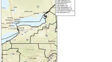
In Wyoming, up to 10 inches of additional snow is expected in the Sierra Madre and Snowy Range. Outdoor activities, especially for hikers and snow-mobilers, may become life-threatening. Whiteout conditions, strong winds and very low temperatures may cause people to become disoriented, while frostbite and hypothermia could develop quickly.
In Utah, mountain areas above 7,000 feet are expected to see heavy snow. Areas near Brian Head and the Tushar Range may receive up to 12 inches, while the Wasatch Plateau, Book Cliffs, Upper Cottonwoods and Uinta Mountains could get 10 to 15 inches by Thursday evening.
Read more news like this on www.timesnownews.com