
Guwahati: Assam's urban centres are getting significantly hotter, with rising land surface temperatures, shrinking green cover and expanding built-up areas transforming cities into growing heat islands.
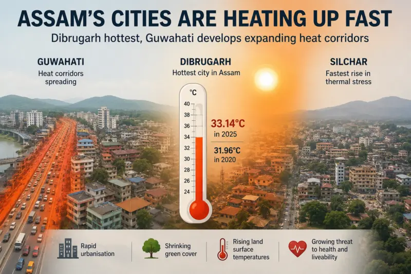
Dibrugarh has emerged as the state's hottest city, with average land surface temperatures increasing from 31.96°C in 2020 to 33.14°C in 2025.
Meanwhile, Guwahati is witnessing the emergence of continuous "heat corridors", while Silchar is experiencing one of the fastest increases in thermal stress, according to a new study by the Directorate of Town and Country Planning, Assam.
The report, Urban Heat Effects in Assam, analysed changes in land surface temperatures, vegetation cover and ward-level heat patterns in Guwahati, Dibrugarh and Silchar between 2020 and 2025. It found that rapid urban expansion, declining vegetation and increasing concretisation are intensifying heat across all three cities.
Prepared by GIS GeoHub and the Assam Urban Knowledge Hub under the Directorate of Town and Country Planning, the study warns that urban heat is emerging as a major environmental, public health and liveability challenge in Assam's rapidly urbanising regions.
The report notes that heat is no longer confined to isolated hotspots but is increasingly becoming a structural feature of urban landscapes.
"The observed transition from relatively fragmented and localised hotspots toward larger and more interconnected thermal zones indicates that urban heat is increasingly becoming a structural component of the urban landscape rather than an isolated environmental condition," the report stated.
The study found that even moderate increases in built-up areas and the loss of ecological buffers are generating disproportionately high thermal impacts at the ward level, pushing some urban areas towards what it describes as a critical threshold beyond which heat stress may intensify rapidly.
Among the three cities, Dibrugarh recorded the highest absolute land surface temperatures. The report described its heat pattern as "compact but more intense", driven by a dense urban core with limited green buffers. It recommended targeted tree plantation, shaded streets and localised cooling interventions to reduce persistent heat exposure.
In Guwahati, previously scattered heat pockets have merged into continuous heat corridors, particularly along the southern expansion belt, GS Road, the Guwahati Bypass and major transport routes.
"Critical wards doubled from 10 to 20" within just five years, the report noted, describing it as one of the clearest indicators that heat stress is spreading spatially across the city.
Guwahati's area-weighted land surface temperature increased by 1°C between 2020 and 2025. During the same period, built-up area expanded from 71.7% to 74.8%, while green cover declined from 23.8% to 21.3%.
The report said Guwahati has the "largest thermal improvement gap" and the greatest green cover deficit among the three cities. It recommended large-scale urban greening, wetland conservation and corridor-based ecological restoration to mitigate rising temperatures.
The study also highlighted growing pressure on Deepor Beel and the city's remaining wetlands and hills, which continue to function as critical cooling zones amid increasing urban heat. Satellite imagery included in the report shows ongoing encroachment and fragmentation around the wetland ecosystem.
Silchar, meanwhile, has recorded one of the fastest transitions towards higher thermal risk. Areas such as Bilpar, Rangirkhari, Sonai Road and Link Road have witnessed rapid densification, increasing traffic pressure and significant vegetation loss, contributing to rising temperatures.
The report warned that Silchar currently has the lowest green cover among the three cities and stressed that early intervention is essential to prevent further thermal deterioration.
According to the study, the three cities are following distinct thermal trajectories: Guwahati through corridor-based heat expansion linked to transport-led urban growth; Dibrugarh through concentrated thermal intensity in its compact urban core; and Silchar through a rapidly intensifying heat transition driven by shrinking green cover and increasing surface sealing.
The report also cited broader climate trends affecting Assam. It noted that the state's annual mean temperature increased by 0.59°C between 1951 and 2010 and could rise by as much as 2.2°C by 2050 under projected climate scenarios.
The findings place the observed urban heat patterns within the larger context of a warming regional climate.
Describing urban heat as an increasingly serious planning and public health challenge, the study called for proactive, spatially informed urban planning that identifies emerging heat-risk zones early, protects ecological cooling systems and integrates climate-responsive measures into infrastructure development and master planning processes.
Explained: How Buddhist nationalism enabled repression in post-coup Myanmar