





Kohima: A comprehensive geospatial study led by Nagaland University has mapped rapid environmental degradation in Kohima district using advanced Geographic Information System (GIS) modelling and remote sensing techniques, offering critical insights for sustainable development and climate resilience planning in the North East Hill (NEH) region.
The study, conducted by researchers from Nagaland University and PNG Government PG College, Ramnagar (Nainital), highlights significant land-use changes, emerging climate trends and seismic vulnerability in the district. The findings are expected to support policymakers and planners in designing evidence-based environmental management strategies across the region.
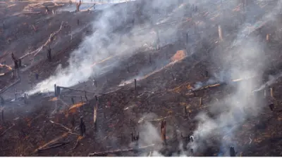
Addressing growing concerns about environmental degradation in the Himalayan and North East Hill regions, the research examined the combined impact of rapid urbanisation, deforestation, shifting cultivation practices and climate change. These factors are contributing to increased risks of landslides, floods, droughts and extreme weather events.
Highlighting the significance of the research, Nagaland University Vice-Chancellor Prof Jagadish K. Patnaik said the study presents a comprehensive geospatial assessment of environmental transformation in Kohima and offers valuable inputs for sustainable development planning in the region.
The findings were published in December 2023 in the peer-reviewed journal Environmental Monitoring and Assessment, published by Springer Nature.
The paper was co-authored by Dr Khrieketouno Belho and Prof M. S. Rawat from the Department of Geography, School of Sciences, Nagaland University, along with Dr Pradeep Kumar Rawat from the Uttarakhand Open University Study Centre. The research was supported by Nagaland University through a Non-NET Fellowship awarded to Dr Belho and by the Ministry of Tribal Affairs, Government of India.
According to Prof M. S. Rawat, the North East Hill region is geo-environmentally fragile due to continuous seismotectonic activity, unstable geological formations, steep terrain and a high frequency of natural hazards such as landslides and slope failures. He noted that increasing land-use degradation is accelerating broader environmental challenges, including climate change and its associated impacts.
"The region is passing through alarming environmental conditions. If necessary mitigation measures are not taken immediately, the impacts could become severe," he said, stressing the importance of adopting reliable geospatial technologies and action-oriented environmental management strategies.
Using an integrated GIS database modelling system, the researchers analysed environmental change through three major modules-Geodiversity Informatics, Land Use Informatics and Climate Informatics. The framework enabled the team to examine geological structures, land-use patterns, vegetation cover, rainfall trends, temperature variation and ecological habitats in an integrated manner.
The study found that natural landscapes, including forests, scrublands and water bodies, declined from 93.93 per cent to 81.86 per cent over the past two decades. At the same time, built-up areas, agricultural land and wasteland increased due to expanding human activity.
Researchers also recorded a steady rise in average temperature at a rate of about 0.13°C per year, accompanied by declining annual rainfall and fewer rainy days.
The study further highlighted the region's geological vulnerability. Analysis of earthquake records between 1982 and 2022 showed that more than 1,100 seismic events were recorded in Kohima district, averaging around 27 micro-earthquakes annually, mostly associated with tectonic faults and geological lineaments that contribute to landscape instability and erosion.
According to the researchers, these changes indicate three major forms of environmental degradation in the region-geodiversity degradation, ecological degradation and climatic degradation. Together, these processes are increasing the likelihood of extreme rainfall events, floods, erosion and other geo-hydrological hazards affecting ecosystems, agriculture and settlements.
Dear Reader,
Every day, our team at EastMojo travels through rain, rough roads, and remote hills to bring you stories that matter - stories from your town, your people, your Northeast.
We do this because we believe in truthful, independent journalism. No big corporate backing, no government pressure - just honest reporting by local journalists who live and breathe the same air you do.
But to keep doing this work, we need you. Your small contribution helps us pay our reporters fairly, reach places others ignore, and keep asking the tough questions.
If you believe the Northeast deserves its own fearless voice, stand with us.
Support independent journalism. Be a Member.
Thank you,
Karma Paljor
Editor-in-Chief, eastmojo.com

Arunachal: New ginger species discovered in Siang Valley

Nagaland tops Northeast in export readiness, mixed results for other states

From Nido Tania to Anjel Chakma: Did the Bezbaruah Committee fail?

When autonomy is undermined: KHADC and the hollowing of tradition
Protest to Purpose: What Swami Vivekananda still demands of India's youth

Explainer: Why Nagaland's only airport is still waiting for expansion clearance

Sacrificing our future: Why FTII Arunachal students are protesting

Two frog species discovered in Arunachal, study highlights Brahmaputra's role
Dr Khrieketouno Belho said the North East Hill region remains highly vulnerable to monsoon-related hazards and climate change impacts due to its geo-environmental and socio-economic characteristics.
The researchers emphasised the need for evidence-based planning and sustainable land management strategies in environmentally sensitive hill regions. By integrating geospatial technologies with environmental datasets, the study provides a comprehensive framework for understanding environmental risks and strengthening climate adaptation strategies in Nagaland and the wider Himalayan landscape.
| Nagaland records 25% growth in GST collection in FY 2025-26